
Pilot's Guide


190-00663-03 Rev. A
Garmin G1000 Pilot’s Guide for the Beechcraft C90A/GT/GTi
337
HAZARD AVOIDANCE
TURBULENCE
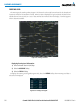
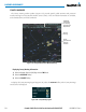
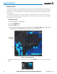
The Turbulence weather product (Figure 6-43) identifies the potential for erratic movement of high-altitude
air mass associated winds. Turbulence is classified as light, moderate, severe or extreme, at altitudes between
21,000 and 45,000 feet. Turbulence information is intended to supplement AIRMETs, SIGMETs, and PIREPs.
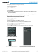
Displaying Turbulence data:
1) Select the Weather Data Link (XM) Page.
2) Select the
MORE WX
Softkey.
3) Select the
TURB
Softkey.
4) Select the desired altitude level: 21,000 feet up to 45,000 feet. Selects the
NEXT
or
PREV
Softkey to cycle
through the altitude softkeys. The
TURB
Softkey label changes to indicate the altitude selected.
Figure 6-43 Turbulence Data at 21,000 Feet
Severe
Turbulence
Moderate
Turbulence
Light
Turbulence
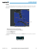
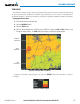
To display the Turbulence legend (Figure 6-44), select the
LEGEND
Softkey when Turbulence is enabled
for display.
Figure 6-44 Turbulence Legend