
Pilot's Guide


190-00663-03 Rev. A
Garmin G1000 Pilot’s Guide for the Beechcraft C90A/GT/GTi
331
HAZARD AVOIDANCE
WINDS ALOFT
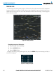
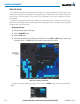
The Winds Aloft weather product (Figure 6-31) shows the forecast wind speed and direction at the surface
and at selected altitudes. Altitude can be displayed in 3000-foot increments beginning at the surface up to
42,000 feet MSL.
Displaying the Winds Aloft weather product:
1) Select the Weather Data Link (XM) Page with the
FMS
Knob.
2) Select the
MORE WX
Softkey.
3) Select the
WIND
Softkey.
4) Select the desired altitude level: SFC (surface) up to 42,000 feet. Select the
NEXT
or
PREV
Softkey to cycle
through the altitude softkeys. The
WIND
Softkey label changes to reflect the altitude selected.
Figure 6-31 Winds Aloft at 21,000 Feet
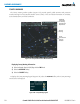
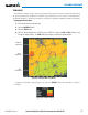
To display the Winds Aloft legend (Figure 6-32), select the LEGEND Softkey when Winds Aloft is
selected for display.
Figure 6-32 Winds Aloft Data with Legend