
Pilot's Guide


Garmin G1000 Pilot’s Guide for the Beechcraft C90A/GT/GTi
190-00663-03 Rev. A328
HAZARD AVOIDANCE
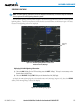
Displaying original METAR text on the Active Flight Plan Page:
1) Select the Active Flight Plan Page on the MFD.
2) Press the FMS Knob to activate the cursor.
3) Turn the large FMS Knob to highlight a waypoint with an available METAR (indicated with a METAR flag next
to it). The METAR text will appear in the ‘SELECTED WAYPOINT WEATHER’ window below.
4) When finished, press the FMS Knob to remove the cursor or press the FPL Key to exit the Active Flight Plan
Page.
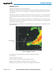
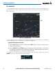
To display the METAR legend (Figure 6-26) on the Weather Data Link (XM) Page, select the LEGEND
Softkey when METARs are selected for display.
The METAR flag color is determined by the information in the METAR text. The system displays a gray
METAR flag when the system cannot determine the METAR category based on the information available.
Figure 6-26 METAR Legend
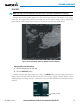
SURFACE ANALYSIS AND CITY FORECAST
NOTE: Surface Analysis and City Forecast data are displayed only within the installed Aviation Database
service area.
Surface Analysis and City Forecast (Figure 6-27) information is available for current and forecast weather
conditions. Forecasts are available for intervals of 12, 24, 36, and 48 hours.