
Pilot's Guide


190-00663-03 Rev. A
Garmin G1000 Pilot’s Guide for the Beechcraft C90A/GT/GTi
323
HAZARD AVOIDANCE
SIRIUSXM LIGHTNING
NOTE: SiriusXM Lightning information cannot be displayed simultaneously on the same map as information
from an optional on-board lightning detection system.
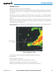
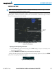
The SiriusXM Lightning weather product (Figure 6-18) shows the approximate location of cloud-to-ground
lightning strikes. A strike icon represents a strike that has occurred within a two-kilometer region. The exact
location of the lightning strike is not displayed.
Lightning
Strikes
Figure 6-18 SiriusXM Lightning Weather Product on the
Weather Data Link (XM) Page
Displaying SiriusXM Lightning information:
1) Select the MAP Softkey (for the PFD Inset Map, press the INSET Softkey). This step is not necessary on the
Weather Data Link (XM) Page.
2) Select the XM LTNG Softkey (LTNG Softkey on the Weather Data Link (XM) Page).
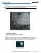
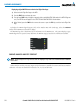
To display the XM Lightning legend on the Weather Data Link (XM) Page (Figure 6-19), select the
LEGEND
Softkey when XM Lightning is selected for display.
Figure 6-19 SiriusXM Lightning Legend