
Pilot's Guide


190-00663-03 Rev. A
Garmin G1000 Pilot’s Guide for the Beechcraft C90A/GT/GTi
291
FLIGHT MANAGEMENT
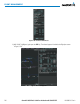
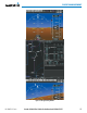
13) Note the altitude constraints associated with each of the approach waypoints as seen in Figure 5-130. These
altitudes are loaded from the database and are displayed as white text, indicating these values are “not
designated” for use in computing vertical deviation guidance.
Note: To use the displayed altitude for calculating vertical deviation guidance, perform the following:
a) Press the FMS Knob to activate the cursor.
b) Turn the small FMS Knob to highlight the desired altitude.
c) Press the ENT Key.
d) Press the FMS Knob to deactivate the cursor.
After making the altitude “designated”, it is displayed as cyan text.
Altitude constraint values associated with the Final Approach Fix (FAF) and waypoints beyond the FAF cannot be
designated for vertical guidance. These altitude values are always displayed as white text, as in Figure 5-130.
Vertical guidance from the FAF and on to the Missed Approach Point (MAP) is given using the SBAS GPS altitude
source, therefore, the displayed altitude values are for reference only.
Figure 5-130 Vertical Guidance is Active to the FAF