
User manual


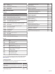

Table Of Contents
- Table of Contents
- Introduction
- Customizing the Chartplotter
- Home Screen
- Customizing Pages
- Presets
- Setting the Vessel Type
- Adjusting the Backlight
- Adjusting the Color Mode
- Turning On the Chartplotter Automatically
- Enabling Screen Lock
- Automatically Turning Off the System
- ActiveCaptain App
- Communication with Wireless Devices
- Charts and 3D Chart Views
- Navigation Chart and Fishing Chart
- Premium Charts
- Automatic Identification System
- Chart Menu
- Supported Maps
- Garmin Quickdraw Contours Mapping
- Mapping a Body of Water Using the Garmin Quickdraw Contours Feature
- Adding a Label to a Garmin Quickdraw Contours Map
- Garmin Quickdraw Community
- Garmin Quickdraw Contours Settings
- Navigation with a Chartplotter
- Basic Navigation Questions
- Destinations
- Waypoints
- Marking Your Present Location as a Waypoint
- Creating a Waypoint at a Different Location
- Marking an SOS Location
- Projecting a Waypoint
- Viewing a List of all Waypoints
- Editing a Saved Waypoint
- Moving a Saved Waypoint
- Browsing for and Navigating to a Saved Waypoint
- Deleting a Waypoint or an MOB
- Deleting All Waypoints
- Routes
- Creating and Navigating a Route From Your Present Location
- Creating and Saving a Route
- Viewing a List of Routes and Auto Guidance Paths
- Editing a Saved Route
- Browsing for and Navigating a Saved Route
- Browsing for and Navigating Parallel to a Saved Route
- Initiating a Search Pattern
- Deleting a Saved Route
- Deleting All Saved Routes
- Auto Guidance
- Tracks
- Showing Tracks
- Setting the Color of the Active Track
- Saving the Active Track
- Viewing a List of Saved Tracks
- Editing a Saved Track
- Saving a Track as a Route
- Browsing for and Navigating a Recorded Track
- Deleting a Saved Track
- Deleting All Saved Tracks
- Retracing the Active Track
- Clearing the Active Track
- Managing the Track Log Memory During Recording
- Configuring the Recording Interval of the Track Log
- Boundaries
- Deleting All Saved Waypoints, Tracks, Routes, and Boundaries
- Sailing Features
- Sonar Fishfinder
- Stopping the Transmission of Sonar Signals
- Changing the Sonar View
- Traditional Sonar View
- Garmin ClearVü Sonar View
- SideVü Sonar View
- Panoptix Sonar Views
- Selecting the Transducer Type
- Selecting a Sonar Source
- Creating a Waypoint on the Sonar Screen
- Pausing the Sonar Display
- Viewing Sonar History
- Sonar Sharing
- Adjusting the Level of Detail
- Adjusting the Color Intensity
- Sonar Recordings
- Traditional, Garmin ClearVü, and SideVü Sonar Setup
- Setting the Zoom Level on the Sonar Screen
- Setting the Scroll Speed
- Adjusting the Range of the Depth or Width Scale
- Sonar Noise Rejection Settings
- Sonar Appearance Settings
- Sonar Alarms
- Advanced Sonar Settings
- Traditional, Garmin ClearVü, and SideVü Transducer Installation Settings
- Sonar Frequencies
- Turning On the A-Scope
- Panoptix Sonar Setup
- Zooming in a Panoptix LiveVü or LiveScope Sonar View
- Adjusting the RealVü Viewing Angle and Zoom Level
- Adjusting the RealVü Sweep Speed
- LiveVü Forward and FrontVü Sonar Menu
- LiveVü and FrontVü Appearance Settings
- RealVü Appearance Settings
- LiveScope and Perspective Sonar Menu
- LiveScope and Perspective Sonar Setup
- LiveScope and Perspective Appearance Settings
- Panoptix Transducer Installation Settings
- Radar
- Radar Interpretation
- Transmitting Radar Signals
- Adjusting the Radar Range
- MotionScope™ Doppler Radar Technology
- Enabling a Guard Zone
- MARPA
- Echo Trails
- Radar Settings
- Selecting a Different Radar Source
- Changing the Radar Mode
- Autopilot
- Force® Trolling Motor Control
- Digital Selective Calling
- Gauges and Graphs
- inReach® Messages
- Digital Switching
- Dometic® Optimus® Features
- Tide, Current, and Celestial Information
- Warning Manager
- Media Player
- Opening the Media Player
- Selecting the Media Device and Source
- Playing Music
- Adjusting the Volume
- VHF Radio
- Radio
- DAB Playback
- SiriusXM Satellite Radio
- Setting the Device Name
- Updating the Media Player Software
- SiriusXM Weather
- SiriusXM Equipment and Subscription Requirements
- Weather Data Broadcasts
- Weather Warnings and Weather Bulletins
- Changing the Weather Chart
- Viewing Precipitation Information
- Forecast Information
- Viewing Fish Mapping Data
- Viewing Sea Conditions
- Viewing Sea Temperature Information
- Visibility Information
- Viewing Buoy Reports
- Weather Overlay
- Viewing Weather Subscription Information
- Viewing Video
- Selecting a Video Source
- Networked Video Devices
- Configuring the Video Appearance
- Garmin VIRB® Action Cameras
- HDMI Out Video Considerations
- Pairing the GC™ 100 Camera with a Garmin Chartplotter
- Device Configuration
- Sharing and Managing User Data
- Appendix
- Index

GPSMAP 12x3 Specifications
Dimensions (W × H × D) 308.3 × 227.6 × 81.8 mm (12
1
/
8
×
8
15
/
16
× 3
1
/
4
in.)
Clearance to next obstruction 18.7 mm (
3
/
4
in.)
Display size (W × H) 262.1 × 164.2 mm (10
15
/
16
× 6
7
/
16
in.)
30.7 cm (12.1 in.) diagonal
Display resolution WXGA, 1280 × 800 pixels
Weight 3.0 kg (6.6 lb.)
Compass-safe distance 45 cm (17.72 in.)
Max. power usage at 10 Vdc Non-sonar models: 26.5 W
Sonar models: 43.0 W
Typical current draw at
12 Vdc
Non-sonar models: 1.67 A
Sonar models: 1.68 A
Max. current draw at 12 Vdc Non-sonar models: 2.15 A
Sonar models: 3.56 A
Temperature range From -15° to 55°C (from 5° to 131°F)
Material Polycarbonate plastic and die-cast
aluminum
Water rating IEC 60529 IPX7
1
Input voltage From 10 to 32 Vdc
Fuse 6 A, 125 V fast-acting
NMEA 2000 LEN @ 9 Vdc 2
NMEA 2000 draw 75 mA max.
Max. waypoints 5,000
Max. routes 100
Max. active track points 50,000 points, 50 saved tracks
Wireless frequency 2.4 GHz @ 17.6 dBm nominal
Memory card 2 microSD card slots; 32 GB max. card
size
Sonar Models Specifications
Specification Measurement
Sonar frequencies
2
Traditional: 50/200, 77/200, 83/200 kHz
Single Channel CHIRP: from 40 to 250 kHz
Garmin ClearVü CHIRP: 260/455/800 kHz
Ultra High-Definition Garmin ClearVü: 0.8 Mhz
(800 kHz), CHIRP range: 760 to 880 kHz
Ultra High-Definition SideVü: 1.2 MHz
(1,200 kHz), CHIRP range: 1,060 to 1,170 kHz
Sonar transmit power
(RMS)
3
CHIRP: 1000 W
Garmin ClearVü and SideVü CHIRP: 500 W
Sonar depth
4
5,000 ft. at 1 kW
NMEA 2000 PGN Information
Transmit and Receive
PGN Description
059392 ISO acknowledgment
059904 ISO request
060160 ISO transport protocol: Data transfer
060416 ISO transport protocol: Connection management
060928 ISO address claimed
065240 Commanded address
126208 Request group function
126996 Product information
126998 Configuration information
127237 Heading/track control
127245 Rudder
1
The device withstands incidental exposure to water of up to 1 m for up to 30 min.
For more information, go to www.garmin.com/waterrating.
2
Dependent upon the transducer.
3
Dependent upon the transducer rating and depth.
4
Dependent upon the transducer, water salinity, bottom type, and other water
conditions.
PGN Description
127250 Vessel heading
127258 Magnetic variance
127488 Engine parameters: Rapid update
127489 Engine parameters: Dynamic
127493 Transmission parameters: Dynamic
127505 Fluid level
127508 Battery status
128259 Speed: Water referenced
128267 Water depth
129025 Position: Rapid update
129026 COG and SOG: Rapid update
129029 GNSS position data
129283 Cross track error
129284 Navigation data
129539 GNSS DOPs
129540 GNSS satellites in view
130060 Label
130306 Wind data
130310 Environmental parameters (obsolete)
130311 Environmental parameters (obsolete)
130312 Temperature (obsolete)
Transmit
PGN Description
126464 Transmit and receive PGN list group function
126984 Alert Response
127497 Trip parameters: Engine
Receive
PGN Description
065030 Generator average basic AC quantities (GAAC)
126983 Alert
126985 Alert text
126987 Alert threshold
126988 Alert value
126992 System time
127251 Rate of turn
127257 Attitude
127498 Engine parameters: Static
127503 AC input status (obsolete)
127504 AC output status (obsolete)
127506 DC detailed status
127507 Charger status
127509 Inverter status
128000 Nautical leeway angle
128275 Distance log
129038 AIS class A position report
129039 AIS class B position report
129040 AIS class B extended position report
129044 Datum
129285 Navigation: Route, waypoint information
129794 AIS class A static and voyage related data
129798 AIS SAR aircraft position report
129799 Radio frequency/mode/power
129802 AIS safety-related broadcast message
129808 DSC call Information
129809 AIS class B "CS" static data report, part A
129810 AIS class B "CS" static data report, part B
Appendix 69