
User manual


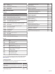

Table Of Contents
- Table of Contents
- Introduction
- Customizing the Chartplotter
- Home Screen
- Customizing Pages
- Presets
- Setting the Vessel Type
- Adjusting the Backlight
- Adjusting the Color Mode
- Turning On the Chartplotter Automatically
- Enabling Screen Lock
- Automatically Turning Off the System
- ActiveCaptain App
- Communication with Wireless Devices
- Charts and 3D Chart Views
- Navigation Chart and Fishing Chart
- Premium Charts
- Automatic Identification System
- Chart Menu
- Supported Maps
- Garmin Quickdraw Contours Mapping
- Mapping a Body of Water Using the Garmin Quickdraw Contours Feature
- Adding a Label to a Garmin Quickdraw Contours Map
- Garmin Quickdraw Community
- Garmin Quickdraw Contours Settings
- Navigation with a Chartplotter
- Basic Navigation Questions
- Destinations
- Waypoints
- Marking Your Present Location as a Waypoint
- Creating a Waypoint at a Different Location
- Marking an SOS Location
- Projecting a Waypoint
- Viewing a List of all Waypoints
- Editing a Saved Waypoint
- Moving a Saved Waypoint
- Browsing for and Navigating to a Saved Waypoint
- Deleting a Waypoint or an MOB
- Deleting All Waypoints
- Routes
- Creating and Navigating a Route From Your Present Location
- Creating and Saving a Route
- Viewing a List of Routes and Auto Guidance Paths
- Editing a Saved Route
- Browsing for and Navigating a Saved Route
- Browsing for and Navigating Parallel to a Saved Route
- Initiating a Search Pattern
- Deleting a Saved Route
- Deleting All Saved Routes
- Auto Guidance
- Tracks
- Showing Tracks
- Setting the Color of the Active Track
- Saving the Active Track
- Viewing a List of Saved Tracks
- Editing a Saved Track
- Saving a Track as a Route
- Browsing for and Navigating a Recorded Track
- Deleting a Saved Track
- Deleting All Saved Tracks
- Retracing the Active Track
- Clearing the Active Track
- Managing the Track Log Memory During Recording
- Configuring the Recording Interval of the Track Log
- Boundaries
- Deleting All Saved Waypoints, Tracks, Routes, and Boundaries
- Sailing Features
- Sonar Fishfinder
- Stopping the Transmission of Sonar Signals
- Changing the Sonar View
- Traditional Sonar View
- Garmin ClearVü Sonar View
- SideVü Sonar View
- Panoptix Sonar Views
- Selecting the Transducer Type
- Selecting a Sonar Source
- Creating a Waypoint on the Sonar Screen
- Pausing the Sonar Display
- Viewing Sonar History
- Sonar Sharing
- Adjusting the Level of Detail
- Adjusting the Color Intensity
- Sonar Recordings
- Traditional, Garmin ClearVü, and SideVü Sonar Setup
- Setting the Zoom Level on the Sonar Screen
- Setting the Scroll Speed
- Adjusting the Range of the Depth or Width Scale
- Sonar Noise Rejection Settings
- Sonar Appearance Settings
- Sonar Alarms
- Advanced Sonar Settings
- Traditional, Garmin ClearVü, and SideVü Transducer Installation Settings
- Sonar Frequencies
- Turning On the A-Scope
- Panoptix Sonar Setup
- Zooming in a Panoptix LiveVü or LiveScope Sonar View
- Adjusting the RealVü Viewing Angle and Zoom Level
- Adjusting the RealVü Sweep Speed
- LiveVü Forward and FrontVü Sonar Menu
- LiveVü and FrontVü Appearance Settings
- RealVü Appearance Settings
- LiveScope and Perspective Sonar Menu
- LiveScope and Perspective Sonar Setup
- LiveScope and Perspective Appearance Settings
- Panoptix Transducer Installation Settings
- Radar
- Radar Interpretation
- Transmitting Radar Signals
- Adjusting the Radar Range
- MotionScope™ Doppler Radar Technology
- Enabling a Guard Zone
- MARPA
- Echo Trails
- Radar Settings
- Selecting a Different Radar Source
- Changing the Radar Mode
- Autopilot
- Force® Trolling Motor Control
- Digital Selective Calling
- Gauges and Graphs
- inReach® Messages
- Digital Switching
- Dometic® Optimus® Features
- Tide, Current, and Celestial Information
- Warning Manager
- Media Player
- Opening the Media Player
- Selecting the Media Device and Source
- Playing Music
- Adjusting the Volume
- VHF Radio
- Radio
- DAB Playback
- SiriusXM Satellite Radio
- Setting the Device Name
- Updating the Media Player Software
- SiriusXM Weather
- SiriusXM Equipment and Subscription Requirements
- Weather Data Broadcasts
- Weather Warnings and Weather Bulletins
- Changing the Weather Chart
- Viewing Precipitation Information
- Forecast Information
- Viewing Fish Mapping Data
- Viewing Sea Conditions
- Viewing Sea Temperature Information
- Visibility Information
- Viewing Buoy Reports
- Weather Overlay
- Viewing Weather Subscription Information
- Viewing Video
- Selecting a Video Source
- Networked Video Devices
- Configuring the Video Appearance
- Garmin VIRB® Action Cameras
- HDMI Out Video Considerations
- Pairing the GC™ 100 Camera with a Garmin Chartplotter
- Device Configuration
- Sharing and Managing User Data
- Appendix
- Index

your cartography and a quick, mobile way to download new
charts using the OneChart
™
feature, provides a link to receive
notifications on your chartplotter, and provides access to the
ActiveCaptain Community for feedback on marinas and other
boating points of interest. You can also use the app to plan
your trip and sync user data. The app checks your devices
for available updates, and notifies you when an update is
available.
Garmin Express: The Garmin Express desktop app allows you
to use your computer and a memory card to download and
update Garmin chartplotter software and charts (Garmin
Express App, page 65). You should use the Garmin
Express app for faster data transfer of larger downloads and
updates, and to avoid possible data charges with some
mobile devices.
Function ActiveCaptain
mobile app
Garmin
Express
desktop app
Register your new Garmin Marine
device
Yes Yes
Update your Garmin chartplotter
software
Yes Yes
Update your Garmin charts Yes Yes
Download new Garmin charts Yes Yes
Access the Garmin Quickdraw
Contours Community to download
and share contours with other users
Yes No
Monitor and track your boat with the
OnDeck system
Yes No
Sync a mobile device with your
Garmin chartplotter
Yes No
Access the ActiveCaptain
Community for feedback on
marinas and boating points of
interest
Yes No
Receive smart notification on the
chartplotter
Yes No
Garmin Express App
The Garmin Express desktop app allows you to use your
computer and a memory card to download and update Garmin
device software and charts and register your devices. We
recommend it for larger downloads and updates for faster data
transfer and to avoid possible data charges with some mobile
devices.
Installing the Garmin Express App on a Computer
You can install the Garmin Express app on a Windows
®
or Mac
®
computer.
1
Go to garmin.com/express.
2
Select Download for Windows or Download for Mac.
3
Follow the on-screen instructions.
Registering Your Device Using the Garmin Express
App
NOTE: You should use the ActiveCaptain app and a mobile
device to register the device (Getting Started with the
ActiveCaptain App, page 6).
Help us better support you by completing our online registration
today. Keep the original sales receipt, or a photocopy, in a safe
place.
1
Install the Garmin Express app on your computer (Installing
the Garmin Express App on a Computer, page 65).
2
Insert a memory card into the card slot (Memory Cards,
page 2).
3
Wait a few moments.
The chartplotter opens the card management page and
creates a file named GarminDevice.xml in the Garmin folder
on the memory card.
4
Remove the memory card from your device.
5
Open the Garmin Express app on your computer.
6
Insert the memory card into your computer.
7
If necessary, select Get Started.
8
If necessary, while the application searches, select Sign In
next to Have marine charts or devices? near the bottom of
the screen.
9
Create or sign in to your Garmin account.
10
Follow the on-screen instructions to set up your vessel.
11
Select Add.
The Garmin Express application searches the memory card
for the device information.
12
Select Add Device to register the device.
When registration is complete, the Garmin Express
application searches for additional charts and chart updates
for your device.
When you add devices to the chartplotter network, repeat these
steps to register the new devices using the Garmin Express app.
Updating Your Charts Using the Garmin Express App
This device supports up to a 32 GB memory card, formatted to
FAT32 with speed class 4 or higher. Use of an 8 GB or higher
memory card with speed class 10 is recommended.
Downloading the chart update may take up to a few hours.
You should use a blank memory card for chart updates. The
update process erases the content on the card and reformats
the card.
1
Install the Garmin Express app on your computer (Installing
the Garmin Express App on a Computer, page 65).
2
Open the Garmin Express app on your computer.
3
Select your vessel and device.
4
If chart updates are available, select Chart Updates >
Continue.
5
Read and agree to the terms.
6
Insert your chartplotter chart memory card into the computer.
7
Select the drive for the memory card.
8
Review the reformat warning, and select OK.
9
Wait while the chart update is copied to the memory card.
NOTE: Copying the update file onto the card may take from a
few minutes up to a few hours.
10
Close the Garmin Express app.
11
Eject the memory card from the computer.
12
Turn on the chartplotter.
13
After the home screen appears, insert the memory card into
the card slot.
NOTE: In order for the update instructions to appear, the
device must be fully booted before the card is inserted.
14
Select Update Software > Yes.
15
Wait several minutes while the update process completes.
16
When prompted, leave the memory card in place, and restart
the chartplotter.
17
Remove the memory card.
NOTE: If the memory card is removed before the device
restarts fully, the update is not complete.
Software Updates
You may need to update the software when you install a new
device or add an accessory.
Appendix 65