
User manual


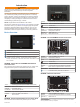
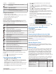
Table Of Contents
- Table of Contents
- Introduction
- Customizing the Chartplotter
- Home Screen
- Customizing Pages
- Presets
- Setting the Vessel Type
- Adjusting the Backlight
- Adjusting the Color Mode
- Turning On the Chartplotter Automatically
- Enabling Screen Lock
- Automatically Turning Off the System
- ActiveCaptain App
- Communication with Wireless Devices
- Charts and 3D Chart Views
- Navigation Chart and Fishing Chart
- Premium Charts
- Automatic Identification System
- Chart Menu
- Supported Maps
- Garmin Quickdraw Contours Mapping
- Mapping a Body of Water Using the Garmin Quickdraw Contours Feature
- Adding a Label to a Garmin Quickdraw Contours Map
- Garmin Quickdraw Community
- Garmin Quickdraw Contours Settings
- Navigation with a Chartplotter
- Basic Navigation Questions
- Destinations
- Waypoints
- Marking Your Present Location as a Waypoint
- Creating a Waypoint at a Different Location
- Marking an SOS Location
- Projecting a Waypoint
- Viewing a List of all Waypoints
- Editing a Saved Waypoint
- Moving a Saved Waypoint
- Browsing for and Navigating to a Saved Waypoint
- Deleting a Waypoint or an MOB
- Deleting All Waypoints
- Routes
- Creating and Navigating a Route From Your Present Location
- Creating and Saving a Route
- Viewing a List of Routes and Auto Guidance Paths
- Editing a Saved Route
- Browsing for and Navigating a Saved Route
- Browsing for and Navigating Parallel to a Saved Route
- Initiating a Search Pattern
- Deleting a Saved Route
- Deleting All Saved Routes
- Auto Guidance
- Tracks
- Showing Tracks
- Setting the Color of the Active Track
- Saving the Active Track
- Viewing a List of Saved Tracks
- Editing a Saved Track
- Saving a Track as a Route
- Browsing for and Navigating a Recorded Track
- Deleting a Saved Track
- Deleting All Saved Tracks
- Retracing the Active Track
- Clearing the Active Track
- Managing the Track Log Memory During Recording
- Configuring the Recording Interval of the Track Log
- Boundaries
- Deleting All Saved Waypoints, Tracks, Routes, and Boundaries
- Sailing Features
- Sonar Fishfinder
- Stopping the Transmission of Sonar Signals
- Changing the Sonar View
- Traditional Sonar View
- Garmin ClearVü Sonar View
- SideVü Sonar View
- Panoptix Sonar Views
- Selecting the Transducer Type
- Selecting a Sonar Source
- Creating a Waypoint on the Sonar Screen
- Pausing the Sonar Display
- Viewing Sonar History
- Sonar Sharing
- Adjusting the Level of Detail
- Adjusting the Color Intensity
- Sonar Recordings
- Traditional, Garmin ClearVü, and SideVü Sonar Setup
- Setting the Zoom Level on the Sonar Screen
- Setting the Scroll Speed
- Adjusting the Range of the Depth or Width Scale
- Sonar Noise Rejection Settings
- Sonar Appearance Settings
- Sonar Alarms
- Advanced Sonar Settings
- Traditional, Garmin ClearVü, and SideVü Transducer Installation Settings
- Sonar Frequencies
- Turning On the A-Scope
- Panoptix Sonar Setup
- Zooming in a Panoptix LiveVü or LiveScope Sonar View
- Adjusting the RealVü Viewing Angle and Zoom Level
- Adjusting the RealVü Sweep Speed
- LiveVü Forward and FrontVü Sonar Menu
- LiveVü and FrontVü Appearance Settings
- RealVü Appearance Settings
- LiveScope and Perspective Sonar Menu
- LiveScope and Perspective Sonar Setup
- LiveScope and Perspective Appearance Settings
- Panoptix Transducer Installation Settings
- Radar
- Radar Interpretation
- Transmitting Radar Signals
- Adjusting the Radar Range
- MotionScope™ Doppler Radar Technology
- Enabling a Guard Zone
- MARPA
- Echo Trails
- Radar Settings
- Selecting a Different Radar Source
- Changing the Radar Mode
- Autopilot
- Force® Trolling Motor Control
- Digital Selective Calling
- Gauges and Graphs
- inReach® Messages
- Digital Switching
- Dometic® Optimus® Features
- Tide, Current, and Celestial Information
- Warning Manager
- Media Player
- Opening the Media Player
- Selecting the Media Device and Source
- Playing Music
- Adjusting the Volume
- VHF Radio
- Radio
- DAB Playback
- SiriusXM Satellite Radio
- Setting the Device Name
- Updating the Media Player Software
- SiriusXM Weather
- SiriusXM Equipment and Subscription Requirements
- Weather Data Broadcasts
- Weather Warnings and Weather Bulletins
- Changing the Weather Chart
- Viewing Precipitation Information
- Forecast Information
- Viewing Fish Mapping Data
- Viewing Sea Conditions
- Viewing Sea Temperature Information
- Visibility Information
- Viewing Buoy Reports
- Weather Overlay
- Viewing Weather Subscription Information
- Viewing Video
- Selecting a Video Source
- Networked Video Devices
- Configuring the Video Appearance
- Garmin VIRB® Action Cameras
- HDMI Out Video Considerations
- Pairing the GC™ 100 Camera with a Garmin Chartplotter
- Device Configuration
- Sharing and Managing User Data
- Appendix
- Index

Table of Contents
Introduction.....................................................................1
Device Overview......................................................................... 1
GPSMAP 7x2/7x2 Plus and GPSMAP 9x2/9x2 Plus
Connector View......................................................................1
GPSMAP 12x2 Touch/A12/12x2 Plus Connector View......... 1
GPSMAP 7x3 and GPSMAP 9x3 Connector View................ 1
GPSMAP 12x3 Connector View............................................ 1
Using the Touchscreen.......................................................... 2
On-Screen Buttons................................................................ 2
Locking and Unlocking the Touchscreen............................... 2
Tips and Shortcuts (MFD models).............................................. 2
Accessing Owner's Manuals on the Chartplotter........................ 2
Downloading the Manuals from the Web.................................... 2
Garmin Support Center...............................................................2
Memory Cards............................................................................ 2
Inserting Memory Cards (GPSMAP 7x2/9x2/12x2
Touch/A12/7x2 Plus/9x2 Plus/12x2 Plus).............................. 3
Inserting Memory Cards (GPSMAP 7x3/9x3/12x3)............... 3
Acquiring GPS Satellite Signals..................................................3
Selecting the GPS Source..................................................... 3
Customizing the Chartplotter........................................ 3
Home Screen.............................................................................. 3
Adding an Item to Favorites................................................... 4
Customizing the Home Screen.............................................. 4
Customizing Pages..................................................................... 4
Customizing the Layout of a SmartMode or Combination
Page.......................................................................................4
Changing the Background Image.......................................... 4
Recommended Background Image Dimensions............... 4
Customizing the Startup Screen............................................ 4
Recommended Startup Image Dimensions...................... 4
Adding a SmartMode Layout................................................. 4
Creating a New Combination Page....................................... 5
Deleting a Combination Page................................................ 5
Customizing the Data Overlays............................................. 5
Resetting the Station Layouts................................................ 5
Presets........................................................................................5
Saving a New Preset............................................................. 5
Managing Presets.................................................................. 5
Setting the Vessel Type.............................................................. 5
Adjusting the Backlight............................................................... 5
Adjusting the Color Mode........................................................... 5
Turning On the Chartplotter Automatically................................. 5
Enabling Screen Lock................................................................. 6
Automatically Turning Off the System........................................ 6
ActiveCaptain App......................................................... 6
ActiveCaptain Roles................................................................... 6
Getting Started with the ActiveCaptain App............................... 6
Enabling Smart Notifications.......................................................6
Receiving Notifications...........................................................7
Managing Notifications...........................................................7
Making Notifications Private...................................................7
Updating Software with the ActiveCaptain App.......................... 7
Updating Charts with ActiveCaptain........................................... 7
Communication with Wireless Devices........................ 7
Wi‑Fi Network............................................................................. 8
Setting Up the Wi‑Fi Wireless Network.................................. 8
Connecting a Wireless Device to the Chartplotter................. 8
Changing the Wireless Channel............................................ 8
Changing the Wi‑Fi Host........................................................ 8
Wireless Remote Control............................................................ 8
Pairing the Wireless Remote Control With the
Chartplotter............................................................................ 8
Turning On and Off the Remote Backlight
............................. 8
Disconnecting the Remote from All Chartplotters.................. 8
Wireless Wind Sensor................................................................ 8
Connecting a Wireless Sensor to the Chartplotter................. 8
Adjusting the Wind Sensor Orientation.................................. 8
Viewing Boat Data on a Garmin Watch...................................... 8
Viewing Boat Data on a Garmin Nautix™ Device...................... 9
Charts and 3D Chart Views........................................... 9
Navigation Chart and Fishing Chart........................................... 9
Zooming In and Out Using the Touchscreen......................... 9
Chart Symbols....................................................................... 9
Measuring a Distance on the Chart....................................... 9
Creating a Waypoint on the Chart..........................................9
Viewing Location and Object Information on a Chart............ 9
Viewing Details about Navaids............................................ 10
Navigating to a Point on the Chart....................................... 10
Premium Charts........................................................................ 10
Fish Eye 3D Chart View....................................................... 10
Viewing Tide Station Information......................................... 10
Animated Tide and Current Indicators............................ 10
Showing Tides and Current Indicators............................ 11
Showing Satellite Imagery on the Navigation Chart............ 11
Viewing Aerial Photos of Landmarks................................... 11
Automatic Identification System................................................11
AIS Targeting Symbols........................................................ 11
Heading and Projected Course of Activated AIS Targets.... 11
Activating a Target for an AIS Vessel.................................. 12
Viewing Information about a Targeted AIS Vessel......... 12
Deactivating a Target for an AIS Vessel......................... 12
Viewing a List of AIS and MARPA Threats.......................... 12
Setting the Safe-Zone Collision Alarm................................. 12
AIS Aids to Navigation......................................................... 12
AIS Distress Signals............................................................ 12
Navigating to a Distress Signal Transmission................. 12
AIS Distress Signal Device Targeting Symbols.............. 12
Enabling AIS Transmission Test Alerts........................... 12
Turning Off AIS Reception................................................... 13
Chart Menu............................................................................... 13
Chart Layers........................................................................ 13
Chart Layer Settings....................................................... 13
Depth Layer Settings.......................................................13
My Vessel Layer Settings................................................13
Laylines Settings............................................................. 13
User Data Layer Settings................................................ 14
Other Vessels Layer Settings..........................................14
Water Layer Settings.......................................................14
Depth Range Shading..................................................... 14
Weather Layer Settings...................................................14
Radar Overlay Settings................................................... 15
Chart Settings...................................................................... 15
Fish Eye 3D Settings........................................................... 15
Supported Maps....................................................................... 15
Garmin Quickdraw Contours Mapping....................... 15
Mapping a Body of Water Using the Garmin Quickdraw
Contours Feature...................................................................... 15
Adding a Label to a Garmin Quickdraw Contours Map............ 15
Garmin Quickdraw Community................................................. 15
Connecting to the Garmin Quickdraw Community with
ActiveCaptain....................................................................... 16
Downloading Garmin Quickdraw Community Maps Using
ActiveCaptain.................................................................. 16
Sharing Your Garmin Quickdraw Contours Maps with the
Garmin Quickdraw Community Using ActiveCaptain...... 16
Connecting to the Garmin Quickdraw Community with
Garmin Connect................................................................... 16
Table of Contents i