
User manual
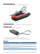
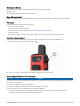
Table Of Contents
- Table of Contents
- Getting Started
- inReach Features
- Testing the Device
- Syncing inReach Data
- Contacts
- Using the Main Pages
- Connected Features
- Navigation
- Weather
- Data Use and History
- Main Menu Tools
- BirdsEye Imagery
- Geocaches
- Setting a Proximity Alarm
- Sending and Receiving Data Wirelessly
- Selecting a Profile
- Calculating the Size of an Area
- Using the VIRB Remote
- Using the Flashlight
- Satellite Page
- Customizing the Device
- Customizing the Data Fields
- Setup Menu
- Device Information
- Appendix

Cleaning the Device
1 Wipe the device using a cloth dampened with a mild detergent solution.
2 Wipe it dry.
After cleaning, allow the device to dry completely.
Data Management
NOTE: The device is not compatible with Windows
®
95, 98, Me, Windows NT
®
, and Mac
®
OS 10.3 and earlier.
File Types
The handheld device supports these file types:
• Files from Garmin Explore.
• GPX route, track, and waypoint files.
• GPX geocache files (Downloading Geocaches Using a Computer, page 30).
• JPEG photo files.
• GPI custom POI files from the Garmin POI Loader. Go to www.garmin.com/products/poiloader.
Installing a Memory Card
You can install a microSD memory card, up to 32 GB, for additional storage or pre-loaded maps.
1 Lift the weather cap on the side of the device .
2 Insert the memory card with the gold contacts facing the front of the device.
Connecting the Device to Your Computer
NOTICE
To prevent corrosion, thoroughly dry the USB port, the weather cap, and the surrounding area before charging or
connecting to a computer.
1 Pull up the weather cap from the USB port.
2 Plug the small end of the USB cable into the USB port on the device.
3 Plug the large end of the USB cable into a computer USB port.
Your device and memory card (optional) appear as removable drives in My Computer on Windows
computers and as mounted volumes on Mac computers.
Device Information 45