
User manual
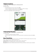
Table Of Contents
- Table of Contents
- Getting Started
- inReach Features
- Testing the Device
- Syncing inReach Data
- Contacts
- Using the Main Pages
- Connected Features
- Navigation
- Weather
- Data Use and History
- Main Menu Tools
- BirdsEye Imagery
- Geocaches
- Setting a Proximity Alarm
- Sending and Receiving Data Wirelessly
- Selecting a Profile
- Calculating the Size of an Area
- Using the VIRB Remote
- Using the Flashlight
- Satellite Page
- Customizing the Device
- Customizing the Data Fields
- Setup Menu
- Device Information
- Appendix

Setup Menu
Select MENU twice, and select Setup.
System: Allows you to customize system settings (System Settings, page 35).
Display: Adjusts the backlight and display settings (Display Settings, page 36).
Bluetooth: Pairs your device to a smartphone, and allows you to customize the Bluetooth settings (Bluetooth
Settings, page 36).
Wi-Fi: Allows you to connect to wireless networks (Wi‑Fi Settings, page 36).
Tracking: Allows you to customize the Tracking settings (inReach Tracking Settings, page 8).
Messages: Allows you to customize the settings for messages (Messages Settings, page 7).
Contacts: Allows you to add, delete, and edit contacts (Contacts, page 10).
Map: Sets the map appearance (Map Settings, page 11).
Recording: Allows you to customize activity recording settings (Recording Settings, page 22).
Routing: Allows you to customize how the device calculates routes for each activity (Routing Settings,
page 37).
Expedition Mode: Allows you to customize settings for turning on expedition mode (Turning On Expedition
Mode, page 43).
Waypoints: Allows you to enter a custom prefix for automatically named waypoints.
Tones: Sets the device sounds, such as key tones and alerts (Setting the Device Tones, page 37).
Heading: Allows you to customize the compass heading settings (Heading Settings, page 13).
Altimeter: Allows you to customize the altimeter settings (Altimeter Settings, page 14).
Geocaching: Allows you to customize your geocache settings (Geocaching Settings, page 37).
Sensors: Pairs wireless sensors with your device (Wireless Sensors, page 38).
Fitness: Allows you to customize settings for recording fitness activities (Fitness Settings, page 38).
Marine: Sets the appearance of marine data on the map (Marine Settings, page 38).
Menus: Allows you to customize the page sequence and main menu (Menu Settings, page 39).
Position Format: Sets the geographical position format and datum options (Position Format Settings, page 40).
Units: Sets the units of measure used on the device (Changing the Units of Measure, page 41).
Time: Adjusts the time settings (Time Settings, page 41).
Profiles: Allows you to customize and create new activity profiles (Profiles, page 41).
Reset: Allows you to reset user data and settings (Resetting Data and Settings, page 42).
About: Displays device information, such as the unit ID, software version, regulatory information, and license
agreement (Viewing E-label Regulatory and Compliance Information, page 47).
System Settings
Select Setup > System.
Satellite: Sets the satellite system options (Satellite Settings, page 35).
Text Language: Sets the text language on the device.
NOTE: Changing the text language does not change the language of user-entered data or map data, such as
street names.
Interface: Sets the format of the serial interface (Serial Interface Settings, page 36).
RINEX Logging: Enables the device to write Receiver Independent Exchange Format (RINEX) data to a system
file. RINEX is a data interchange format for raw satellite navigation system data.
Satellite Settings
Select Setup > System > Satellite.
Satellite System: Sets the satellite system to GPS or Demo Mode (GPS off).
WAAS/EGNOS: Enables the system to use Wide Area Augmentation System/European Geostationary Navigation
Overlay Service (WAAS/EGNOS) data.
Customizing the Device 35