
Rotorcraft Flight Manual Supplement


RFMS Garmin G500H as installed in Bell 206A 190-01150-12 Rev. B
FAA APPROVED Page 7 of 24
The Garmin SafeTaxi database contains detailed airport diagrams for selected
airports. These diagrams aid in following air traffic control instructions by
accurately displaying the aircraft position on the map in relation to taxiways,
ramps, runways, terminals, and services. This database is updated on a 56-day
cycle.
The Garmin FliteCharts database contains procedure charts for the coverage area
purchased. This database is updated on a 28-day cycle. If not updated within 180
days of the expiration date, FliteCharts will no longer function.
The Jeppesen ChartView electronic charts database contains procedure charts for
the coverage area purchased. An own-ship position icon will be displayed on
these charts. This database is updated on a 14-day cycle. If not updated within 70
days of the expiration date, ChartView will no longer function.
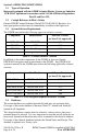
2.5 AHRS Operational Area
The GRS 77 AHRS used in the G500H is limited in its operational area: AHRS
Operation is not assured north of 72°N and south of 70°S latitudes. In addition,
AHRS operation is not assured in the following four regions:
1) North of 65° North latitude between longitude 75° W and 120° W
2) North of 70° North latitude between longitude 70° W and 128° W
3) North of 70° North latitude between longitude 85° E and 114° E
4) South of 55° South latitude between longitude 120° E and 165° E
Loss of the G500H heading and attitude may occur near the poles, but this will
not affect the GPS track.