
Rotorcraft Flight Manual Supplement


190-01150-12 Rev. B RFMS Garmin G500H as installed in Bell 206A
Page 18 of 24 FAA APPROVED
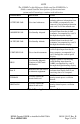
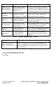
Label
Unit Controlled
PFD
Garmin Display Unit
(PFD/MFD), GDU 620
AHRS
Attitude and Heading
Reference System, GRS
77H
ADC
Air Data Computer, GDC
74H
Navigation Sources
The G500H requires at least one Garmin GPS/WAAS navigation unit to be
installed to ensure the integrity of the Attitude and Heading Reference System.
The AHRS will still operate in reversionary mode if all GPS sources fail, and the
PFD attitude display will still be presented.
The HSI on the G500H can display course deviation information from up to four
sources: GPS 1, GPS 2, VLOC 1, or VLOC 2. In addition, the HSI can display
two simultaneous bearing pointers sourced from GPS 1, GPS 2, VLOC 1, VLOC
2.
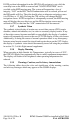
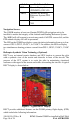
Helicopter Synthetic Vision Technology (Optional)
HSVT uses an internal terrain database and GPS location to present the pilot
with a synthetic view of the terrain and obstacles in front of the aircraft. The
purpose of the SVT system is to assist the pilot in maintaining situational
awareness with regard to the terrain and traffic surrounding the aircraft. A typical
HSVT display is shown below:
Figure 5 - Typical HSVT Display
HSVT provides additional features on the G500H primary flight display (PFD)
which include the following information: