
User Guide


5-87190-00647-00 Rev. A
Garmin G1000 Pilot’s Guide for the Mooney M20M/M20R/M20TN
GPS NAVIGATION
ACCESSING THE CLOSEST POINT OF FLIGHT PLAN WINDOW
‘Closest Point of FPL’ calculates the bearing and closest distance at which a flight plan passes from a
reference waypoint. It can also be used to create a new user waypoint along the flight plan at the location
closest to a chosen reference waypoint.
Determining the closest point along the active flight plan to a selected waypoint:
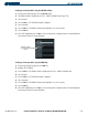
1) From the Active Flight Plan Page, press the
MENU
Key.
2) Select ‘Closest Point of FPL’.
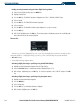
3) Press the
ENT
Key. A window is displayed with the reference waypoint field highlighted.
4) Enter the identifier of the reference waypoint.
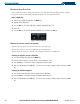
5) Press the
ENT
Key.
6) The G1000 displays the location, lat/lon, bearing (BRG), and distance (DIST) to the closest point along the flight
plan from the selected reference waypoint. To create a user waypoint at this location and add it to the flight plan,
highlight ‘LOAD’ and press the
ENT
Key. The name for the new user waypoint is derived from the identifier of the
reference waypoint.
CHANGING THE CONFIGURABLE DATA FIELDS IN THE WAYPOINT LIST
‘Change Fields’ allows the default fields of DTK (distance) and DIS (distance) to be changed to the
following:
• CUM (cumulative distance)
• DIS (distance)
• DTK (desired track)
• ESA (estimated safe altitude)
• ETA (estimated time of arrival)
• ETE (estimated time enroute)
Changing either the DTK or the DIS field:
1) With the Active Flight Plan Page displayed, press the
MENU
Key.
2) Highlight ‘Change Fields’.
3) Press the
ENT
Key.
4) Highlight the ‘DIS’ or ‘DTK’ field.
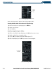
5) Turn the small FMS Kno
b
to display a list of options (Figure 5-74).
6) Select the desired item.
7) Press the
ENT
Key.
8) Press the
FMS K
n
ob
to remove the cursor.