
User Guide


5-3190-00647-00 Rev. A
Garmin G1000 Pilot’s Guide for the Mooney M20M/M20R/M20TN
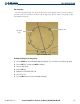
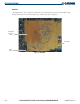
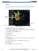
The Navigation Map Page (Figure 5-1) is the first page in the Map Page Group and provides the following
GPS Navigation display capability:
•Map display showing airports, NAVAIDS, airspaces, land data (highways, cities, lakes, rivers, borders, etc.)
with names (labels)
• Map pointer information (distance and bearing to pointer, location of pointer, name and other pertinent
information)
• Map zoom range legend
• Wind direction and speed
• Heading indication
• Aircraft icon representing present position
• Icons for enabled map features
• Track vector
• Topography scale
• Fuel range ring
• Topography data
Selecting the Navigation Map Page:
1) Select the Map Page Group.
2) Select the Navigation Map Page. The page group name and page title (of all pages) are displayed below the
Navigation Data Bar: MAP – NAVIGATION MAP. In addition to turning the FMS Knobs, the Navigation Map
Page can be selected from any page by pressing and momentarily holding the CLR (DFLT MAP) Key.
GPS NAVIGATION