
User Guide


Garmin G1000 Pilot’s Guide for the Diamond DA42
190-00649-00 Rev. A6-38
HAZARD AVOIDANCE
TERRAIN DATA ON THE NAVIGATION MAP PAGE
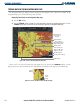
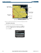
The Navigation Map Page displays terrain and obstacle data (Figure 6-42). Obstacles are shown on the
Navigation Map Page at or below the map range of 20 nm.
Displaying Terrain Data on the Navigation Map Page:
1) Press the
MAP
Softkey.
2) Press the TERRAIN Softkey to display the terrain and obstacle data on the Navigation Map Page. Press the
TERRAIN Softkey again to remove the terrain and obstacle data from the Navigation Map Page.
Aircraft Symbol
Figure 6-42 Terrain on the Navigation Map Page (TIS)
Cursor Placed on
Lighted Obstacle Gives
Height in MSL & AGL
Terrain Legend
Red Terrain Area
(Within 100’ of
Aircraft)
Yellow Terrain Area
(Between 100’ and
1000’ of Aircraft)
MAP Softkey
Terrain Symbol & Range
Lighted Obstacle
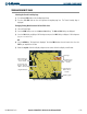
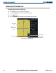
Terrain can be selected on the PFD inset map (Figure 6-43) by pressing the TERRAIN Softkey. Terrain
display may also be deselected from the inset map without affecting the terrain display on the MFD maps.
Figure 6-43 Terrain and Obstacle Data on PFD Inset Map
Range
Terrain
Symbol
Lighted
Obstacle