
User Guide


190-00649-00 Rev. A
Garmin G1000 Pilot’s Guide for the Diamond DA42
6-37
HAZARD AVOIDANCE
6.3 TERRAIN AVOIDANCE
NOTE:
Terrain data is not displayed when the aircraft latitude is greater than 75 degrees north or 60 degrees
south.
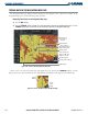
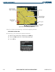
The terrain and obstacle proximity feature provides a situation display of the terrain and obstacles beneath the
aircraft. Terrain elevation is shown relative to the aircraft altitude. Terrain and obstacles that are less than 100 feet
below the aircraft are shown in red. Those between 100 feet and 1000 feet are shown in yellow.
Terrain pop-up windows appear on all pages to inform the pilot of close proximity to the terrain and obstacles.
Terrain information can be displayed on the following:
• Navigation Map Page
• Terrain Map Page
• PFD Inset Map
• AUX - Trip Planning Page
• Active Flight Plan Pages
• VNAV Flight Plan Pages
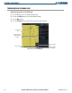
1000 ft AGL
Aircraft Altitude
100 ft Threshold
Figure 6-41 Terrain Proximity Indications
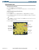
Terrain Color Terrain Location
Red (WARNING) Terrain at or within 100 ft below aircraft altitude
Yellow (CAUTION) Terrain between 100 ft and 1000 ft of aircraft altitude
Black (NO DANGER)
Terrain more than 1000 ft below aircraft altitude
Table 6-3 Terrain Proximity Colors
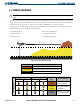
Unlighted Obstacle Lighted Obstacle
Obstacle
Color
Obstacle Location
< 1000 ft AGL > 1000 ft AGL < 1000 ft AGL > 1000 ft AGL
Obstacle Symbol
Red
(WARNING)
Obstacle within 100 ft or
above aircraft altitude
Yellow
(CAUTION)
Obstacle within 1000 ft of
aircraft altitude
Gray
(NO DANGER)
Obstacle more than 1000
ft below aircraft altitude
Table 6-4 Obstacle Symbols and Colors