
User Guide


Garmin G1000 Pilot’s Guide for the Diamond DA42
190-00649-00 Rev. A6-34
HAZARD AVOIDANCE
Selecting Traffic Symbol Range:
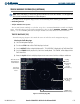
1) With the Navigation Map Page displayed, press the
MENU
Key to display the Navigation Map Page
Menu
. The
cursor flashes on the ‘Map Setup’ Option.
2) Press the
ENT
Key. The Map Setup Menu is displayed.
3) Turn the small
FMS
Knob to select the ‘Traffic’ group. Press the
ENT
Key. The cursor flashes on the ‘TRAFFIC’
Field.
4) Turn the large
FMS
Knob to highlight the ‘TRAFFIC SMBL’ Field. Traffic Symbol ranges extend from Off to
300 nm.
5) Turn the small
FMS
Knob to select the desired range option.
6) Press the
ENT
Key to accept the selected option.
7) Press the
FMS
Knob to return to the Navigation Map Page.
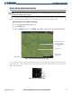
The traffic label displays altitude separation (above or below the symbol) and the vertical speed sense arrow
to the right of the symbol.
Selecting a Traffic Label Range:
1) With the Navigation Map Page displayed, press the
MENU
Key to display the Navigation Map Page
Menu
. The
cursor flashes on the ‘Map Setup’ Option.
2) Press the
ENT
Key. The Map Setup Menu is displayed.
3) Turn the small
FMS
Knob to select the ‘Traffic’ group. Press the
ENT
Key. The cursor flashes on the ‘TRAFFIC’
field.
4) Turn the large
FMS
Knob to highlight the ‘TRAFFIC LBL’ Field. Traffic Label ranges extend from Off to 300 nm.
5) Turn the small
FMS
knob to select the desired range option.
6) Press the
ENT
Key to accept the selected option.
7) Press the
FMS
Knob
to return to the Navigation Map Page.