
User Guide


190-00649-00 Rev. A
Garmin G1000 Pilot’s Guide for the Diamond DA42
6-19
HAZARD AVOIDANCE
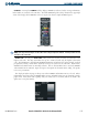
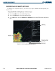
FRZ LVL – Pressing the FRZ LVL Softkey displays contour lines for freezing levels. The update rate is
every 12 minutes.
Figure 6-25 Freezing Level Legend
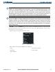
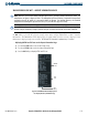
WIND – Pressing the WIND Softkey shows wind speed and direction at a selected altitude from the
ground up to 42,000 feet in 3,000 foot increments. The WIND Softkey label changes to reflect the winds
aloft altitude selected. The wind direction is toward the dot on the wind vector line. The update rate is every
12 minutes.
Figure 6-26 Winds Aloft Legend
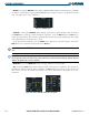
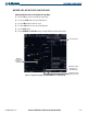
COUNTY – pressing the COUNTY Softkey provides specific public awareness and protection weather
warnings for Tornado, Severe Thunderstorm, and Flood conditions provided by the National Weather Service
(NWS). Refer to the Legend for a description of the county warning icon. The update rate is every 5
minutes.
Figure 6-27 County Warnings Legend
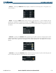
CYCLONE – pressing the CYCLONE Softkey shows the current location of cyclones and their projected
track at various time intervals. The update rate is every 12 minutes.
Figure 6-28 Cyclone Legend