
User Guide


Garmin G1000 Pilot’s Guide for the Diamond DA42
190-00649-00 Rev. A6-16
HAZARD AVOIDANCE
Colors are used to identify the different NEXRAD echo intensities (reflectivity) measured in dBZ (decibels
of Z). “Reflectivity” is the amount of transmitted power returned to the radar receiver. Reflectivity
(designated by the letter Z) covers a wide range of signals (from very weak to very strong). So, a more
convenient number for calculations and comparison, a decibel (or logarithmic) scale (dBZ), is used. The
dBZ values increase as the strength of the signal returned to the radar increases.
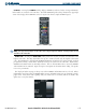
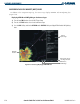
CLD TOP – Pressing the CLD TOP Softkey shows the cloud top altitude determined from satellite
imagery. Refer to Figure 6-19 for a depiction of the CLOUD TOPS color coding. The update rate is every
15 minutes.
Figure 6-19 Cloud Tops Legend
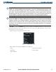
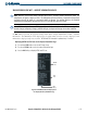
NOTE: Strike depiction represents cloud to ground strikes within a 2 kilometer radius of the actual strike
location. Therefore, the exact location of the strike is not displayed.
LTNG – Pressing the LTNG Softkey shows the approximate location of cloud-to-ground lightning strikes.
The update rate is every five minutes.
Figure 6-20 Lightning Legend
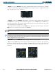
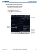
CELL MOV – Pressing the CELL MOV Softkey shows the storm cells identified by the ground-based
system. The movement is depicted by an arrow. The update rate is every 1.25 minutes.
Figure 6-21 Cell Movement Legend