
User Guide


5-140 190-00649-00 Rev. A
Garmin G1000 Pilot’s Guide for the Diamond DA42
GPS NAVIGATION
5.14 PFD INSET MAP AND PFD WINDOWS
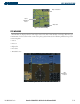
GPS navigation operations on the Primary Flight Display centers around the use of the Inset Map and Display
Windows (Figures 5-95 and 5-96).
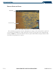
INSET MAP
The Inset Map is a smaller version of the MFD Navigation Map and is optionally displayed in the lower left
corner of the PFD when the system is not in reversionary mode. The Inset Map is displayed by pressing the INSET
Softkey. Inset Map features are enabled on the MFD (refer to the Navigation Map Setup section for details).
NOTE: The Inset Map is removed from the PFD any time aircraft pitch is greater than +30° or less than –20°,
or when a 65° bank angle is reached.
NOTE: Inset Map operations involving the display of traffic, terrain, and weather data are discussed in the
Hazard Awareness section.
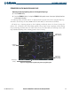
The Inset Map can display the following information:
• Moving map
• Zoom scale legend
• Orientation
• Aircraft icon
• TOPO data (optional)
• Traffic data (optional)
• Weather data (optional)
• Terrain data (optional)
• Indication of which map features are enabled
• Active navigation flight plan
• Track vector
• Wind direction/speed
• Latitude/longitude lines
• NAV range ring
• Fuel range ring (reserve; the fuel reserve rings are enabled and disabled from the MFD only)
• Obstacles data
• Potential terrain/obstacle impact data (TAWS / TERRAIN units)