
User Guide


5-113190-00649-00 Rev. A
Garmin G1000 Pilot’s Guide for the Diamond DA42
GPS NAVIGATION
5.13 NAVIGATION MAP CONFIGURATION (MFD)
WARNING: Use of the MFD Navigation Map for pilotage navigation is prohibited. The Navigation Map is
intended only to enhance situational awareness. Navigation is to be conducted using only current charts,
data, and authorized navigation facilities.
This section describes the MFD Navigation Map Page setup and operation which in most cases will be a “one-
time” operation since the setup can be customized to accommodate the individual needs of the pilot.
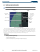
NAVIGATION MAP PAGE
NOTE: MFD Navigation Map operations involving the display of traffic, terrain, and weather data are
described in the Hazard Awareness Section of the Pilot’s Guide.
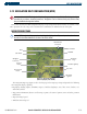
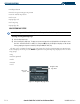
Figure 5-78 Navigation Map Page
(not all map display items shown)
Topo Scale
Nav Range
Ring
Map Range
Legend
Map Orientation
Wind Direction
and Speed
Interstate Highway
Navigation
Course Line
Non-Towered
Airport
Towered
Airport
VOR/DME
State Border
MOA
The Navigation Map Page (Figure 5-78) is the first page in the Map Page Group and provides the following
GPS Navigation display capability:
•Map display showing airports, NAVAIDS, airspaces, land data (highways, cities, lakes, rivers, borders, etc.)
with names (labels)
• Map pointer information (distance and bearing to pointer, location of pointer, name and other pertinent
information)
• Map zoom range legend
• Wind direction and speed