
User Guide


5-75190-00649-00 Rev. A
Garmin G1000 Pilot’s Guide for the Diamond DA42
GPS NAVIGATION
WPT - USER WAYPOINT INFORMATION
Reference
Waypoints
Map of
Surrounding Area
General Location
User Waypoint
Symbol
Comment
User Waypoint
List with
Comments
User Waypoint
Name and Symbol
Latitude/Longitude
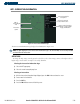
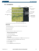
Figure 5-49 User WPT Information Page
Second Reference
Waypoint with
Identifier and
Bearing
Number of
Waypoint Slots
Used/Available
The G1000 allows the storage of up to 1,000 user-defined waypoints. The User Waypoint Information Page
(Figure 5-49) displays the waypoint name (up to six characters long), identifier, and radial from two reference
waypoints, distance from one reference waypoint, along with the user waypoints latitude/longitude position.
The User Waypoint Information Page displays the information shown in Figure 5-49:
OPERATIONS
The following operations can be performed from the User Waypoint Information Page:
• Creating user waypoints (by current location, entered latitude/longitude position, reference waypoint
specifications, or Map Pointer location)
• Modifying user waypoint information (by comment, latitude/longitude position, or reference waypoint
information)
• Renaming user waypoints
• Deleting user waypoints
Selecting the User WPT Information Page
1) Select the
NRST
page group.
2) Select the fifth rectangular page icon.
CREATING USER WAYPOINTS
User waypoints may be created from the User Waypoint Information Page or the Navigation Map Page.
To create a new user waypoint from the User Waypoint Information Page, enter the name (identifier) and
position, or reference another waypoint by radial and distance.