
User Guide


5-68
GPS NAVIGATION
190-00649-00 Rev. A
Garmin G1000 Pilot’s Guide for the Diamond DA42
WPT – WEATHER INFORMATION
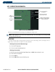
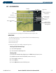
Figure 5-42 Weather Information Page
Airport Identifier
Facility Name
Airport Location
METAR Information
for the Selected
Airport
TAF Information
for the Selected
Airport
Associated
Airport Identifier
Airport Symbol
Airport
Usage
Map of
Surrounding Area
and Selected
Airport
The Weather Information Page displays the information described in Figure 5-42.
Refer to the Hazard Avoidance
Section for detailed information relating to the display and control of optional weather information.
OPERATIONS
Viewing weather:
1) Select the Approach Information Page. Press the
WX
Key.
2) Highlight ‘View Weather’. The Weather Information Page is displayed.
User waypoints can be created from the Weather Information Page Map.
Creating user waypoints using the Weather Information Page Map:
1) With the Weather Information Page displayed, push the Joystick to activate the panning function. The target
pointer is displayed at the center of the map.
2) After placing the pointer at the desired position, press the
ENT
Key. The User Waypoint Information Page is now
displayed with the captured position.
3) Enter a waypoint name. Press the
ENT
Key to accept the selected name. The first reference waypoint field is
highlighted.
4) If desired, enter the identifier of the reference waypoint and the radial and distance to the reference waypoint.
5) Press the
ENT
Key to accept.
6) Press the
FMS
Knob to remove the flashing cursor.