
User Guide


190-00592-01 Rev. A
Garmin G1000 Pilot’s Guide for the Diamond DA40/40F
6-31
HAZARD AVOIDANCE
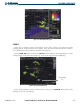
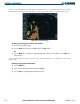
Map Range (No
Obstacles Shown
Beyond 10 nm)
Black Terrain Area
(More than 1000’
Below Aircraft Altitude)
Red Terrain Area
(Above or Within 100’
Below Aircraft Altitude
Yellow Terrain Area
(Between 100’ and
1000’ Below Aircraft
Altitude
Figure 6-41 Terrain Proximity Page (ARC View)
Terrain Legend
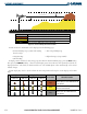
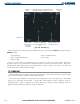
NAVIGATION MAP PAGE
Terrain and obstacle data can be displayed on the Navigation Map Page (as shown in Figure 6-42). Obstacles
are shown on the Navigation Map Page at or below the map range of 20 nm.
Displaying Terrain Data on the Navigation Map Page:
1) Press the
MAP
Softkey.
2) Press the TERRAIN Softkey to display the terrain and obstacle data on the Navigation Map Page.
3) Press the TERRAIN Softkey again to remove the terrain and obstacle data from the Navigation Map Page.
Cursor Placed
o n L i g h t e d
Obstacle
Aircraft Symbol
Yellow Terrain
Area (Between
100’ and 1000’
Below Aircraft
Altitude
Terrain Legend
Terrain Symbol
and Range
R e d L i g h t e d
Obstacles (Above
or Within 100’
Below Aircraft
Altitude
Red Terrain
Area (Above
or Within 100’
Below Aircraft
Altitude)
Figure 6-42 Terrain Information on the Navigation Map Page