
User Guide


Garmin G1000 Pilot’s Guide for the Diamond DA40/40F
190-00592-01 Rev. A6-24
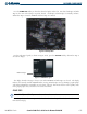
HAZARD AVOIDANCE
WINDS ALOFT
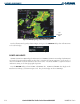
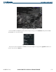
Winds Aloft data (as shown in Figure 6-34) shows the wind speed and wind direction at a selected altitude.
The speed and direction can be displayed from the ground up to 42,000 feet in 3,000 ft. increments.
Press the MORE WX
Softkey and then the WIND Softkey to display Winds Aloft data. Press the SFC
Softkey to display the surface wind speed and directions. Press any numbered softkey to display the
altitude in 3,000 foot increments. The WIND Softkey label changes to reflect the altitude selected.
Press the
NEXT Softkey to display the next set of softkeys. Press the PREV Softkey to return to the
previous set of softkeys.
Figure 6-34 Winds Aloft at 27,000 feet with NEXRAD and County Data
For the Winds Aloft legend (as shown in Figure 6-35), press the LEGEND Softkey when Winds Aloft is
selected to be displayed.