
User Guide


Garmin G1000 Pilot’s Guide for the Diamond DA40/40F
190-00592-01 Rev. A6-14
HAZARD AVOIDANCE
• NEXRAD base reflectivity is sampled at the minimum antenna elevation angle. An individual NEXRAD
site cannot depict high altitude storms at close ranges. It has no information about storms directly over
the site.
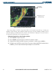
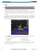
• The resolution of displayed NEXRAD data is four square kilometers (as shown in Figure 6-13). Therefore,
when zoomed in on the display, each square block represents a four-square kilometer area. The intensity
level reflected by the square is the highest level sampled within the area.
Block has an area
of 4 sq. km
Figure 6-13 NEXRAD Data - Zoomed
NEXRAD radar images may display abnormalities. These include but are not limited to:
• Ground clutter
• Strobes and spurious radar data
• Sun strobes (when the radar antenna points directly at the sun)
• Interference from buildings or mountains, which may cause shadows
• Metallic dust from military aircraft, which can cause alterations in radar scans
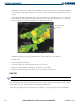
ECHO TOPS
NOTE: Cloud Tops and Echo Tops cannot be turned on at the same time.
Echo Tops data (as shown in Figure 6-14) shows the location, elevation, and direction of the highest radar
echo. The highest radar echo does not indicate the top of a storm or clouds, only the highest altitude at which
precipitation is detected. The information is derived from NEXRAD data.
Echo Tops data displays only on the Weather Data Link Page. It does not display on other G1000 maps.