
User Guide


Garmin G1000 Pilot’s Guide for the Diamond DA40/40F
190-00592-01 Rev. A6-12
HAZARD AVOIDANCE
NEXRAD
NOTE: The TOPO and/or TERRAIN display and NEXRAD are mutually exclusive for all applicable maps.
NEXRAD (NEXt-generation RADar) is a network of 158 high-resolution Doppler radar systems that are
operated by the National Weather Service (NWS). Its technical name is WSR-88D.
NEXRAD data provides centralized meteorological information for the continental United States and selected
overseas locations. The maximum range of a single NEXRAD radar site is 250 nautical miles. In addition to
a wide array of services, the NEXRAD network provides important information about severe weather and air
traffic safety.
NEXRAD data is not real-time. The lapsed time between collection, processing, and dissemination of
NEXRAD images can be significant and may not reflect the current radar synopsis. Due to the inherent delays
and the relative age of the data, it should be used for long-range planning purposes only. Never use NEXRAD
data or any radar data to penetrate hazardous weather. Rather, use it in an early-warning capacity of pre-
departure and enroute evaluation.
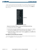
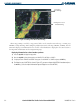
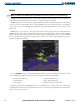
Figure 6-11 NEXRAD Data on the Weather Data Link Page
Press the NEXRAD Softkey to show NEXRAD weather and radar coverage information (as shown in Figure
6-11). NEXRAD data displays on the PFD Inset Map and on the following G1000 maps:
• Weather Data Link Page • Airport Information Page
• Navigation Map • AUX - Trip Planning Page
• Nearest Pages • Flight Plan Pages (except VNAV)
Composite data from all the NEXRAD radar sites in the United States is shown. This data is composed of
the maximum reflectivity from the individual radar sweeps. The display of the information is color-coded to
indicate the weather severity level.