
User Guide


Garmin G1000 Pilot’s Guide for the Diamond DA40/40F
190-00592-01 Rev. A5-38
GPS NAVIGATION
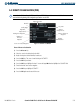
5.6 INTERSECTION INFORMATION
NOTE: The VOR displayed on the Intersection Information Page is the nearest VOR, not necessarily the VOR
used to define the intersection.
Selecting the Intersection Information Page (Figure 5-34):
1) Select the WPT page group.
2) Select the second rectangular page icon. To change the map range, turn the Joystick to the left to select a
lower range, turn it to the right to select a higher range. Intersections can only be selected by identifier.
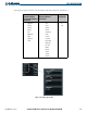
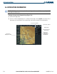
Figure 5-34 Intersection Information Page
Intersection Identifier
Facility Name
Intersection Region
and Position
Nearest VOR
Identifier,
Symbol, Radial
and Distance
Intersection Symbol
Intersection
Displayed on Map