
User Guide


Garmin G1000 Pilot’s Guide for the Diamond DA40/40F
190-00592-01 Rev. A5-36
GPS NAVIGATION
Loading a pilot control lighting frequency into selected COM standby frequency:
1) With the Airport Information Page displayed, press the
FMS
Knob
to activate the cursor.
2) Move the cursor to the ‘PCL FREQ’ field in the ‘Runways’ box.
3) Press the E
NT
Key to place the PCL frequency in the standby field of the COM Frequency Box.
4) Press the
FMS
Knob to remove the cursor.
ADDITIONAL AIRPORT RUNWAY INFORMATION
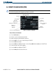
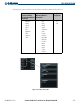
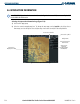
Figure 5-33 Runway Information Box
Runway Surface
Runway Size
Runway Designation
Runway Lighting
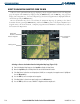
The airport runway information field (Figure 5-33) displays runway designations, length, surface type and
lighting for the selected airport. A map image of the runway layout and surrounding area is also displayed on
the Airport Information Window. The map image range is displayed in the lower left corner and is adjustable
using the Joystick. For airports with multiple runways, information for each runway is available.
Displaying information for each additional runway:
1) Press the FMS Knob to activate the cursor.
2) Place the cursor on the runway designation field.
3) Turn the small FMS Knob to display the next runways for the selected airport.
4) Select the desired runway.
5) Press the FMS Knob to remove the flashing cursor.
6) Turn the Joystick counterclockwise to select a lower range and rotate it clockwise to select a higher range.
The following descriptions and abbreviations are used on the airport runway information box:
• Type – Usage type: Public, Military, or Private
• Surface – Runway surface types include: Hard, Turf, Sealed, Gravel, Dirt, Soft, Unknown, or Water
• Lighting – Runway lighting types include: No Lights, Part Time, Full Time, Unknown, or Frequency (for
pilot-controlled lighting)