
User Guide


190-00592-02 Rev. A
Garmin G1000 Pilot’s Guide for the Diamond DA40/40F
6-5
HAZARD AVOIDANCE
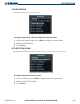
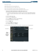
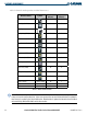
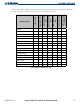
Table 6-2 shows which XM WX Satellite Weather products display on specific pages of the MFD and the PFD
Inset Map. The positive symbols represent the presence of this data on the page.
Weather Product
PFD Inset Map
Navigation Map Page
Weather Data Link
Page
Weather Information
Page
AUX - Trip Planning
Page
Nearest Page Group
Flight Plan Pages
(except VNAV)
NEXRAD + + + + + +
Cloud Top (CLD TOP) +
Echo Top
+
XM Lightning (LTNG)
+ + + + + +
Cell Movement (SCIT) + + + + + +
SIGMETs/AIRMETs (SIG/AIR) +
METARs
+ +
City Forecast (CITY)
+
Surface Analysis (SFC)
+
Freezing Levels (FRZ LVL)
+
Winds Aloft (WIND)
+
County Warnings (COUNTY)
+
Cyclone Warnings (CYCLONE)
+
Radar Coverage
+ +
TFRs + + + + + + +
TAFs
+ +
Table 6-2 Weather Product Display Maps