
User Guide


Garmin G1000 Pilot’s Guide for the Diamond DA40/40F
190-00592-02 Rev. A5-90
GPS NAVIGATION
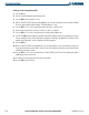
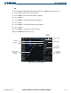
Creating a vertical navigation profile:
1) Press the
FPL
Key.
2) Select the Vertical Navigation Page (third page icon).
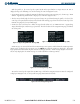
3) Press the
FMS
Knob
to activate the cursor.
4) With the ‘TARGET POSITION’ distance field highlighted, select the desired distance for Top Of Climb or Bottom
Of Descent from the VNAV profile endpoint. The default distance is 4 nm.
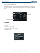
5) Press the
ENT
Key. The cursor is now positioned over the ‘Before’ and ‘After’ field.
6) Select whether the previously set distance is ‘Before’ or ‘After’ the endpoint.
7) Press the
ENT
Key. The cursor is now placed over the VNAV profile endpoint field.
8) Turn the small
FMS
Knob to display a list possible VNAV profile endpoints. When using a flight plan, the target
reference waypoint itself can be specified from the waypoints contained in the flight plan. By default, the last
waypoint in the flight plan is selected. Highlight the desired waypoint.
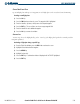
9) Press the
ENT
Key.
10) With the ‘TARGET ALTITUDE’ field highlighted, select the target altitude. If the selected altitude is above the
current aircraft altitude, a profiled climb is created. If the selected altitude is below the current aircraft altitude,
a profiled descent will be created.
11) Press the
ENT
Key. The cursor is now placed in the ‘TARGET VERTICAL SPEED’ field. The default profile utilizes
a 400 foot-per-minute descent rate.
12) To change the vertical speed, enter the desired vertical speed.
13) Press the
ENT
Key when finished.