
User Guide


190-00592-02 Rev. A
Garmin G1000 Pilot’s Guide for the Diamond DA40/40F
5-23
GPS NAVIGATION
GPS NAVIGATION STATUS BOX
Table 5-17 GPS Navigation Status Box
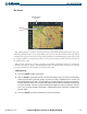
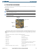
The GPS Navigation Status Box (Figure 5-17) is displayed in the top center of the MFD and PFD. It
displays four, user-configurable fields which can display the information listed below. Instructions on
changing a data field are given in the System Overview section.
• Bearing to next waypoint (BRG)
• Distance to next waypoint (DIS)
• Desired track to next waypoint (DTK)
• Enroute safe altitude (ESA)
• Estimated Time of Arrival (ETA)
• Estimated Time Enroute (ETE)
• Ground Speed (GS)
• Maximum Safe Altitude (MSA)
• Track angle error (TKE)
• Track angle (TRK)
• Vertical speed required (VSR)
• Cross track error (XTK)
• Currently selected MFD page title