
User Guide


Garmin G1000 Pilot’s Guide for the Columbia 350/400
190-00552-00 Rev. A6-44
HAZARD AVOIDANCE
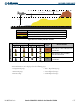
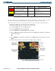
Figure 6-50 TAWS Page (ARC View)
Map Range (No
Obstacles Shown
Beyond 10 NM)
Red Terrain Area
(Above or Within
100’ Below
Aircraft Altitude)
Yellow Terrain Area
(Between 100’
and 1000’ Below
Aircraft Altitude)
Black Terrain Area
(More Than 1000’
below Aircraft
Altitude)
Terrain Legend
360° and ARC
Softkeys
Enable/Disable Aviation Data
1) While the TAWS Page is displayed, press the
MENU
Key.
2) Turn the small
FMS
Knob to select “Show (or Hide) Aviation Data”.
3) Press the
ENT
Key.
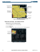
Figure 6-51 TAWS Page Menu
Displaying Terrain and Obstacles on the Navigation Map
1) With the Navigation Map displayed, select the
MAP
Softkey.
2) Select the
TERRAIN
Softkey. Terrain and obstacle proximity will now be displayed on the map.
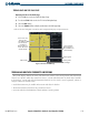
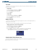
Unlighted Obstacle
(Height is less than
1000’ AGL)
Lighted Obstacle
(Height is less than
1000’ AGL)
Unlighted Obstacle
(Height is greater than
1000’ AGL)
Lighted Obstacle
(Height is greater than
1000’ AGL)
Potential Impact Points
Figure 6-52 TAWS Obstacle Symbols