
User Guide


190-00552-00 Rev. A
Garmin G1000 Pilot’s Guide for the Columbia 350/400
6-37
HAZARD AVOIDANCE
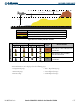
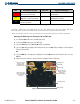
Figure 6-40 Terrain Proximity Indications and Colors
Terrain Color Terrain Location
Red Terrain above, or within 100 ft below the aircraft altitude
Yellow Terrain between 100 ft and 1000 ft below the aircraft altitude
Black
Terrain more than 1000 ft below the aircraft altitude
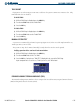
Unlighted Obstacle Lighted Obstacle
Obstacle
Color
Obstacle Location
< 1000 ft AGL > 1000 ft AGL < 1000 ft AGL > 1000 ft AGL
Obstacle Symbol
Red
Obstacle above, or within 100 ft below the
aircraft altitude
Yellow
Obstacle between 100 ft and 1000 ft
below the aircraft altitude
Gray
Obstacle more than 1000 ft below the
aircraft altitude
Table 6-3 Obstacle Symbols and Colors
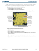
Terrain information can be displayed on the following pages:
• Navigation Map Page
• Terrain Map Page
• PFD Inset Map
• AUX - Trip Planning Page
• Active Flight Plan Pages
• VNAV Flight Plan Pages