
User Guide


Garmin G1000 Pilot’s Guide for the Columbia 350/400
190-00552-00 Rev. A6-32
HAZARD AVOIDANCE
TIS TRAFFIC STATUS
The MFD indicates the following TIS traffic status to the pilot:
• AGE – If traffic data is not refreshed within 6 seconds, an age indicator (i.e., ‘AGE 00:06’) is displayed in
the lower left corner of the display (when displaying traffic). After another 6 seconds, if data is still not
received, the traffic is removed from the display. The quality of displayed traffic is reduced as the AGE
increases.
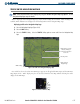
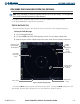
• TRFC COAST – The ‘TRFC COAST’ (traffic coasting) banner located above the AGE timer indicates that
displayed traffic is held even though the data is stale (Figure 6-38). The quality of displayed traffic is
reduced when TRFC COAST is displayed.
• TRFC RMVD – The ‘TRFC RMVD’ banner indicates that traffic has been removed from the display due to
the age of the data being too old to “coast” (for the time period of 12-60 seconds from the last receipt of a
TIS message). Traffic may be present but not shown.
• TA OFF – The ‘TA OFF’ scale banner displayed in the lower left corner of the display indicates that a traffic
advisory is outside the selected display range. The traffic advisory off range banner is removed when the
traffic advisory is within the selected display range.
• TRAFFIC – On the PFD, when the system receives a traffic advisory a flashing ‘TRAFFIC’ alert is displayed
in the upper left-hand portion of the display. The PFD inset map also automatically displays traffic data.
TIS LIMITATIONS
TIS may not be available in the radar coverage areas for several reasons.
• Radar Out – The radar site may be out of service for various reasons. If the TIS Mode S sensor is not
operational, TIS is not available.
• Out of Radar Range – Traffic beyond the maximum Mode S site range will not be shown. If your own
aircraft or any other traffic is beyond the range of the TIS capable Mode S site, TIS is not available.
• Radar Cone of Silence – Whether your own aircraft or the other traffic is above the radar site in the cone
of silence, and out of range of an adjacent site, TIS data will not be received.
• Below Radar Coverage – If your aircraft or the other traffic is below radar coverage it will not be seen. In
flat terrain the coverage extends from about 3000 feet upward at 55 miles. Terrain and obstacles around
the radar site can further decrease radar coverage in all directions.
• No Transponder – Aircraft without an operating transponder are invisible to TIS. Aircraft without altitude
reporting capability are shown without altitude separation data or climb descent indication.