
User Guide


190-00552-00 Rev. A
Garmin G1000 Pilot’s Guide for the Columbia 350/400
6-25
HAZARD AVOIDANCE
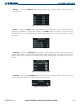
6.2 TRAFFIC AVOIDANCE
NOTE: Aircraft without an operating transponder are invisible to both Traffic Advisory Systems (TAS) and
Traffic Information Service (TIS). Aircraft without altitude reporting capability are shown without altitude
separation data or climb descent indication.
NOTE: For a description of traffic advisory criteria and display interpretation, see the applicable Traffic
Advisory System Pilot’s Guide.
Traffic Avoidance Systems, consisting of Traffic Information Service (TIS) and the optional Traffic Advisory
System (TAS) are designed to help pilots detect and avoid aircraft intersecting their flight path. Both systems use
the Mode S transponder for the traffic data link. Either system may be configured in the aircraft, but not both.
The major difference between the two systems is that TIS is passive, receiving traffic information from ground
stations to provide a five-second update rate. TAS uses an active airborne interrogator to look for close by aircraft,
giving the precise location with a half-second update rate. The TIS and TAS systems have similar ranges and
service volume.
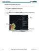
The G1000 displays up to eight traffic targets within a 7.5 nm radius, from 3,000 feet below to 3,500 feet
above the requesting aircraft. Traffic is displayed on the Traffic Map Page according to TCAS symbology. Traffic
is displayed using four different symbols
• Non Threat Traffic—Hollow white diamond
• Proximity Advisories (PA)—Solid white diamond
• Traffic Advisories (TA)—Solid yellow circle
• Traffic Advisory Off Scale—Solid Split Circle, Yellow/Gray
Proximity Advisories (PAs) are defined as traffic within the 5.0-nm range, within ±1200 ft. of altitude separation,
and are not Traffic Advisories (TA). When traffic meets the advisory criteria for the TA a solid yellow circle symbol
is generated.
TIS provides vector lines showing the direction that the aircraft symbol is moving. TAS does not show vector
lines.
Altitude deviation from your aircraft altitude is displayed above the target symbol if they are above your altitude,
and below the symbol if they are below your altitude. Altitude trend is displayed as an up arrow (+500 ft/min),
down arrow (-500 ft/min), or no symbol if less than 500 ft/min rate in either direction. The traffic label displays
altitude separation and the vertical speed sense arrow to the right of the symbol.