
User Guide


Garmin G1000 Pilot’s Guide for the Columbia 350/400
190-00552-00 Rev. A6-22
HAZARD AVOIDANCE
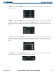
WEATHER DATA ON THE AUX – TRIP PLANNING PAGE MAP
Displaying Weather Data on the Trip Planning Page Map:
1) Turn the large
FMS
Knob to select the AUX Page Group.
2) Press the
FMS
Knob to activate the cursor on the FPL Page.
3) Select the
NEXRAD
and
XM LTNG
Softkeys to display NEXRAD and XM Lightning Data on the Trip Planning
Page Map.
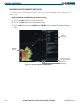
Figure 6-31 AUX – TRIP Planning Page Displaying NEXRAD Weather and XM Lightning
NEXRAD
Weather
AUX Page Group,
First Page Selected
NEXRAD and XM
Lightning Softkeys
Lightning
Indication
NEXRAD and XM
Lightning Icons,
800 NM Range