
User Guide


190-00552-00 Rev. A
Garmin G1000 Pilot’s Guide for the Columbia 350/400
6-15
HAZARD AVOIDANCE
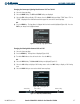
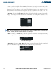
NEXRAD – Selecting the NEXRAD Softkey displays NEXRAD weather and radar coverage information,
both of which are activated at the same time. The small NEXRAD legend is always shown in the upper right
corner of the display when NEXRAD is selected. Figure 6-17 shows a sample NEXRAD legend.
Figure 6-17 NEXRAD Legend
NOTE: Echo Tops and Cloud Tops use the same color scaling to represent altitude. The two products are not
available at the same time.
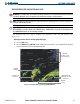
ECHO TOP – Selecting the ECHO TOP Softkey shows the location, elevation, and direction of the
highest radar echo. This may not indicate the top of a storm or clouds, only the highest radar return
echo. The information is derived from NEXRAD information and indicates the highest altitude at which
precipitation is falling. ECHO TOPS and Radar coverage are activated at the same time. ECHO TOPS,
NEXRAD and CLOUD TOPS are mutually exclusive. That is, when ECHO TOPS is activated, NEXRAD
and CLOUD TOPS are removed. Figure 6-18 gives a description of the ECHO TOPS coding. The update
rate is every 7.5 minutes.
The display of Radar Coverage is always active when NEXRAD and ECHO TOPS are selected. Where
information is not being collected, NEXRAD Radar coverage and ECHO TOPS areas are shown in a grayish-
purple color. Areas where radar capability exists, but is not active or is off-line, will not be shown. The
update rate is every five minutes.
Figure 6-18 Echo Tops Legend