
User Guide


5-132 190-00552-00 Rev. A
Garmin G1000 Pilot’s Guide for the Columbia 350/400
GPS NAVIGATION
NAVIGATION MAP OPERATIONS
SELECTING A MAP RANGE
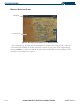
Figure 5-90 Map Range Indicator
Map Range
Indicator
The Navigation Map can be set to 28 different range settings from 500 feet to 2000 nautical miles. The
current range is indicated in the lower right corner of the Navigation Map Page and represents the
top-to-
bottom distance covered by the map
. To change the map range turn, the Joystick counter-clockwise to
zoom in, or clockwise to zoom out.