
User Guide


5-119190-00552-00 Rev. A
Garmin G1000 Pilot’s Guide for the Columbia 350/400
GPS NAVIGATION
Enabling/disabling the Nav Range Ring:
1) Press the
MENU
Key with the Navigation Map Page displayed. The cursor flashes on the ‘Map Setup’ option.
2) Press the
ENT
Key. The Map Setup Menu is displayed.
3) Select the ‘Map’ group.
4) Press the
ENT
Key.
5) Highlight the ‘NAV RANGE RING’ field.
6) Select ‘On’ or ‘Off’.
7) Press the
FMS
Knob
to return to the Navigation Map Page.
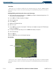
Topo Data
Topographic data can be enabled or disabled on the Navigation Map using the ‘TOPO DATA’ setting.
The topo data range is the maximum map range on which topo data is displayed.
Enabling/disabling topo data and select a topo data range:
1) Press the
MENU
Key with the Navigation Map Page displayed. The cursor flashes on the ‘Map Setup’ option.
2) Press the
ENT
Key. The Map Setup Menu is displayed.
3) Select the ‘Map’ group.
4) Press the
ENT
Key.
3) Highlight the ‘TOPO DATA’ field.
4) Select ‘On’ or ‘Off’.
5) Highlight the range field. TOPO ranges are from Off to 2000 nm.
6) To change the TOPO range setting, turn the
small FMS
Knob to display the range list.
7) Select the desired range.
8) Press the
ENT
Key.
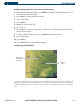
Topo Scale
The topo scale setting enables or disables the topography range box located in the lower right corner
of the Navigation Map.
Enabling/disabling the topo range box:
1) Press the
MENU
Key with the Navigation Map Page displayed. The cursor flashes on the ‘Map Setup’ option.
2) Press the
ENT
Key. The Map Setup Menu is displayed.
3) Select the ‘Map’ group and press the
ENT
Key.
4) Highlight the ‘TOPO Range’ field.
5) Select ‘On’ or ‘Off’.
6) Press the
FMS
Knob
to return to the Navigation Map Page.