
User Guide


5-105190-00552-00 Rev. A
Garmin G1000 Pilot’s Guide for the Columbia 350/400
GPS NAVIGATION
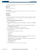
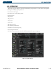
The sky view display at the top left corner of the page shows the satellites currently in view as well as their
respective positions. The outer circle of the sky view represents the horizon with north at the top of the circle;
the inner circle represents 45° above the horizon, and the center point shows the position directly overhead.
Each satellite has a 30-second data transmission that must be collected (hollow signal strength bar) before the
satellite may be used for navigation (solid signal strength bar). Once the GPS receiver has determined position,
the G1000 indicates position, altitude, track, and ground speed. The GPS receiver status box also displays the
following messages under the appropriate conditions:
• Acquiring Sat - The GPS receiver is acquiring satellites for navigation. In this mode, the receiver uses satellite
orbital data (collected continuously from the satellites) and last known position to determine the satellites
that should be in view.
• 2D Navigation - The GPS receiver is in 2D navigation mode.
• 3D Navigation - The GPS receiver is in 3D navigation mode and computes altitude using satellite data.
The Satellite Status Page also indicates the accuracy of the position fix, using Estimated Position Uncertainty
(EPU), Dilution of Precision (DOP), and horizontal and vertical figures of merit (HFOM and VFOM). EPU is
the radius of a circle centered on an estimated horizontal position in which actual position has 95% probability
of laying. The EPU is a statistical error indication, not an actual error measurement. DOP measures satellite
geometry quality (i.e., number of satellites received and where they are relative to each other) on a range from
0.0 to 9.9. The lowest numbers denote the best accuracy and the highest numbers denote the worst. HFOM and
VFOM are the current 95% confidence horizontal and vertical accuracy values reported by the GPS receiver.
OPERATIONS
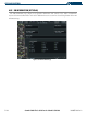
RAIM PREDICTION
NOTE: RAIM computations predict satellite coverage within ±15 min of the specified arrival date and time.
“RAIM” is an acronym for Receiver Autonomous Integrity Monitoring, a GPS receiver function that
performs a consistency check on all tracked satellites. RAIM ensures that the available satellite geometry
will allow the receiver to calculate a position within a specified protection limit (2.0 nautical miles for
oceanic and enroute, 1.0 NM for terminal, and 0.3 NM for non-precision approaches). During oceanic,
enroute, and terminal phases of flight, RAIM is available nearly 100% of the time.
Because of the tighter protection limit on approaches, there may be times when RAIM is not available.
The G1000 automatically monitors RAIM and warns with an alert message when it is not available. If RAIM
is not available when crossing the FAF, the missed approach procedure must be flown.
The RAIM prediction function also indicates whether RAIM will be available for a specified date and
time. If RAIM is not predicted to be available for the final approach course, the approach does not become
active — as indicated by an “Approach is not active” message, and a “RAIM not available from FAF to MAP”
message.
Predicting RAIM availability:
1) Select the GPS Status Page.
2) Press the
FMS
Knob
.