
User Guide


5-68
GPS NAVIGATION
190-00552-00 Rev. A
Garmin G1000 Pilot’s Guide for the Columbia 350/400
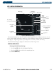
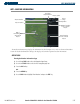
User waypoints can be created from the Weather Information Page Map.
Creating user waypoints using the Weather Information Page Map:
1) With the Weather Information Page displayed, push the
Joystick
to activate the panning function. The target
pointer is displayed at the center of the map.
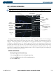
2) After placing the pointer at the desired position, press the
ENT
Key. The User Waypoint Information Page is now
displayed with the captured position.
3) Enter a waypoint name. Press the
ENT
Key to accept the selected name. The first reference waypoint field is
highlighted.
4) If desired, enter the identifier of the reference waypoint and the radial and distance to the reference waypoint.
5) Press the
ENT
Key to accept.
6) Press the
FMS
Knob to remove the flashing cursor.