
User Guide


5-29
GPS NAVIGATION
190-00552-00 Rev. A
Garmin G1000 Pilot’s Guide for the Columbia 350/400
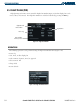
CHANGING THE CONFIGURABLE DATA FIELDS IN THE WAYPOINT LIST
‘Change Fields’ allows the default fields of DTK (distance) and DIS (distance) to be changed to the
following:
• CUM (cumulative distance)
• DIS (distance)
• DTK (desired track)
• ESA (estimated safe altitude)
• ETA (estimated time of arrival)
• ETE (estimated time enroute)
Changing either the DTK or the DIS field:
1) With the Active Flight Plan Page displayed, press the
MENU
Key.
2) Highlight ‘Change Fields’.
3) Press the
ENT
Key.
4) Highlight the ‘DIS’ or ‘DTK’ field.
5) Turn the small FMS Kno
b
to display a list of options (Figure 5-23).
6) Select the desired item.
7) Press the
ENT
Key.
8) Press the
FMS K
n
ob
to remove the cursor.
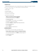
Available
Fields
List
Figure 5-23 Changing Flight Plan Data Fields