
User Guide


190-00552-00 Rev. A
Garmin G1000 Pilot’s Guide for the Columbia 350/400
4-37
AUDIO PANEL AND CNS
TRAFFIC INFORMATION SERVICE (TIS)
NOTE: TIS is intended only to assist in visual acquisition of other aircraft in Visual Meteorological Conditions
(VMC).
NOTE: Aircraft without operating transponders are invisible to TIS.
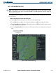
Mode S provides a data link for Traffic Information Service (TIS). TIS is a ground-based service that sends out
location, direction, altitude, and climb/descent information relative to all transponder-equipped aircraft within
a radius of 55 miles from select sites.
For aircraft not equipped with TCAS or TAS, TIS provides a graphic display of traffic information. TIS
displays up to eight traffic targets within 7.5 nautical miles from 3000 feet below to 3500 feet above the aircraft.
TIS data is updated approximately once every five seconds.