
User Guide


Garmin G1000 Pilot’s Guide for Cessna Citation Mustang
190-00494-00 Rev. B6-64
HAZARD AVOIDANCE
6.4 TRAFFIC INFORMATION SERVICE (TIS)
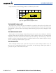
Warning
: The Traffic Information Service (TIS) is intended for advisory use only. TIS is intended to help the
pilot locate traffic visually. It is the responsibility of the pilot to see and maneuver to avoid traffic.
NOTE: TIS is available only when the aircraft is within the service volume of a TIS-capable terminal radar
site. Aircraft without an operating transponder are invisible to both Traffic Advisory Systems (TAS) and TIS.
Aircraft without altitude reporting capability are shown without altitude separation data or climb descent
indication.
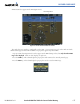
Traffic Information Service (TIS) is designed to help pilots detect and avoid aircraft intersecting their flight
paths. TIS uses the Mode S transponder for the traffic data link. TIS receives traffic information from ground
stations and provides a five-second update rate. The G1000 displays up to eight traffic targets within a 7.5-nm
radius, from 3000 feet below to 3500 feet above the requesting aircraft. Traffic is displayed according to TCAS
symbology using four different symbols (Table 6-10).
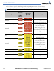
TIS Symbol Description
Non-Threat Traffic
Proximity Advisory (PA)
Traffic Advisory (TA)
Traffic Advisory Off Scale
Table 6-10 TIS Symbol Descriptions
Proximity Advisories (PAs) are defined as traffic within the 5.0-nm range, within ±1200 feet of altitude separation.
They are not Traffic Advisories (TA), which alert the crew to intruding aircraft. When traffic meets the advisory
criteria for the TA, a solid yellow circle symbol is generated. TIS also displays non-bearing traffic, or traffic for
which it is unable to determine the bearing. Non-bearing traffic alert messages display in the center of the Traffic
Map Page.