
User Guide


190-00494-00 Rev. B
Garmin G1000 Pilot’s Guide for Cessna Citation Mustang
6-55
HAZARD AVOIDANCE
TAWS SYMBOLS
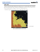
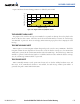
The symbols and colors in Figure 6-59 and Table 6-6 are used to represent obstacles and potential impact
points on the TAWS Page. TAWS uses yellow (caution) and red (warning) to depict terrain information relative
to aircraft altitude.
Potential Impact Point
Unlighted Obstacle
Projected Flight Path
Figure 6-59 Terrain Altitude/Color Correlation for TAWS
Each color is associated with an alert severity level. Terrain graphics and visual annunciations also use these
color assignments.
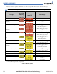
Unlighted Obstacle Lighted Obstacle Potential
Impact
Points
Obstacle Location Alert Level
< 1000’
AGL
> 1000’
AGL
< 1000’
AGL
> 1000’
AGL
Obstacle Symbol
Obstacle at or within 100’
below current aircraft altitude
WARNING
Obstacle between 100’ and
1000’ below current aircraft
altitude
CAUTION
Table 6-6 TAWS Terrain/Obstacle Colors and Symbology
Note that if an obstacle and the projected flight path of the aircraft intersect, the display automatically
zooms in to the closest potential point of impact on the TAWS Page.