
User Guide


190-00494-00 Rev. B
Garmin G1000 Pilot’s Guide for Cessna Citation Mustang
6-25
HAZARD AVOIDANCE
COUNTY
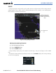
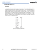
County data (Figure 6-28) provides specific public awareness and protection weather warnings from the
National Weather Service (NWS). This can include information on fires, tornadoes, severe thunderstorms,
flood conditions, and other natural disasters.
Figure 6-28 County Warning Information
Severe Thunderstorm
Icon
Additional Information
About Flood Warning
(Available When Panning
Map)
Displaying County Warning information:
1) Select the Weather Data Link Page.
2) Select the MORE WX Softkey.
3) Select the COUNTY Softkey.
County Warnings display only on the Weather Data Link Page. They do not display on other G1000
maps.
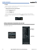
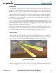
To display the County Warnings legend (Figure 6-29), select the
LEGEND Softkey when County Warnings
are selected to be displayed.
Figure 6-29 County Warnings Legend