
User Guide


190-00494-00 Rev. B
Garmin G1000 Pilot’s Guide for Cessna Citation Mustang
6-23
HAZARD AVOIDANCE
WINDS ALOFT
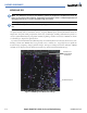
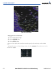
Winds Aloft data (Figure 6-26) shows the forecasted wind speed and direction at the surface and at selected
altitudes. Altitude can be displayed in 3,000-foot increments up to 42,000 feet MSL. Winds Aloft data can
only be displayed on the Weather Data Link Page.
Displaying Winds Aloft data:
1) Select the Weather Data Link Page.
2) Select the
MORE WX
Softkey.
3) Select the
WIND
Softkey.
a) Select the
SFC
Softkey to display the surface wind speed and directions.
b) Select an altitude for which to display data.
c) Select any numbered softkey to display the winds in 3,000 foot altitude increments. The
WIND
Softkey label
changes to reflect the altitude selected.
d) Select the
NEXT
or
PREV
Softkey to display additional altitude softkeys.
Figure 6-26 Winds Aloft Data at 27,000 Feet