
User Guide


Garmin G1000 Pilot’s Guide for Cessna Citation Mustang
190-00494-00 Rev. B6-14
HAZARD AVOIDANCE
Select the LTNG or XM LTNG Softkey to show the location of cloud-to-ground lightning strikes. Lightning
data displays on the following maps:
• PFD Inset Map • Nearest Pages
• Weather Data Link Page • AUX - Trip Planning Page
• Navigation Map • Flight Plan Page
Displaying XM Lightning information:
1) Select the MAP Softkey. For the PFD Inset Map, select the INSET Softkey. This is not necessary for the Weather
Data Link Page.
2) Select the XM LTNG Softkey, or the LTNG Softkey for the Weather Data Link Page.
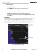
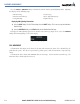
To display the XM Lightning legend on the Weather Data Link Page (Figure 6-13), select the
LEGEND
Softkey when XM Lightning is selected for display.
Figure 6-13 Lightning Legend
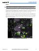
CELL MOVEMENT
Cell Movement data (Figure 6-14) shows the location and movement of storm cells as identified by the
ground-based system. The cells are represented by yellow squares, while the movement is represented by
arrows.
Cell Movement data is shown with NEXRAD data on most maps. On the Weather Data Link Page, Cell
Movement data is shown only when selected.