
User Guide


Garmin G1000 Pilot’s Guide for Cessna Citation Mustang
190-00494-00 Rev. B6-6
HAZARD AVOIDANCE
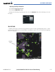
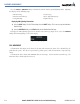
Viewing a weather legend:
1) Select the Map Page Group.
2) Select the Weather Data Link Page.
3) Select the LEGEND Softkey to display the legends for the displayed weather products.
OR:
On the Weather Data Link Page, press the MENU Key, which displays the Page Menu Options. Turn the FMS
Knob to select ‘Weather Legend’ and press the ENT Key.
4) Turn the FMS Knob to scroll through the legends if more are available than fit in the window.
5) To return to the previous page and remove the legend window, select the LEGEND Softkey, the ENT or the CLR
Key, or the FMS Knob.
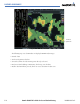
MAP PANNING
Map panning (Figure 6-4) moves the map beyond its current limits without adjusting the map range. If the
map range is changed by turning the
Joystick
while panning, the map is recentered on the pointer.
Press the
Joystick
to select the map panning feature. When map panning is enabled, the Map Pointer
flashes. Panning over AIRMETs, County Warnings, TFRs (Temporary Flight Restrictions), Echo Tops,
METARs, SIGMETs, and Cell Movement displays text information in the top center of the map.
Information
About Warning
Panning Arrow
Over a Flood
Warning
Figure 6-4 Panning on the Weather Data Link Page